ARGUMENT AGAINST NATURAL ORIGIN OF ARSENIC IN GROUNDWATER
Jamal Anwar
(Abstract from Arsenic Poisoning in Bangladesh)
Natural sources of arsenic
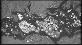
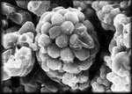
Image left: is a scanning electron micrograph of a thin section. The round blobs are framboidal pyrite, which is suspected to be a candidate arsenic contributor. Image (R) is a close up scanning electron microscope (SEM) of framboidal pyrite. |
- The Himalayas and Low Content of Arsenic in All Geological Formation
- Sea-level Change and the Low Himalayan Ice Melt and a Dryer Climate from Last Glacial Period
- Holocene sediments from the Bay of Bengal
- Pyrite Oxidation
- Basement Complex
- Clay Minerals
- The Catchment Areas of Ganges
- Older Ganges Aquifer (G1) and Younger Geological Units (G2)
- Rivers
- Iron
- Arsenic Concentration at Chittagong Division
- Genesis of Arsenic Concentration
- Rice - IRRI High Yield Producing Countries in River Plain faceing Arsenic Contamination
- Some Examples Of Naturally Occuring Arsenic in Ground Water
- Anthropogenic Source
1. The Himalayas and Low Content of Arsenic in All Geological Formation
Average arsenic concentrations at different geological units which received sediments almost from the same catchments areas and followed by river dominated deltaic deposits show very low arsenic concentration ( BGS, MML, UK, 1998) as follows:
| Geological Formation | Arsenic Concentration mg/kg |
| Bokabil Formation (Pliocene- about 7 million years ago) |
0. 001 |
| Dupitila & Dhing formation (Late Pliocene 4.5 million years ago to Pleistocene) |
0. 002 |
| Girujan Clay Formation (Pleistocene 2.5 million years ago) | 0. 003 |
| Barind Clay Residuum | 0. 001 |
| Madhupur Clay Residium (Late Pleistocene) |
0. 004 |
Note: BGS in their report describes mg/l, but if it is soil sample should be mg/kg.
The BGS (1998) presumes that with the rise of sea level about 18,000 years ago incised valleys surrounding Madhupur and Barind Tracts rapidly filled in “arsenic bearing sand and silt “beds, on the other hand areas not eroded (Madhupur and Barind Tracts) water table fell far below ground level, enhancing flushing, oxidizing organic matter and favouring recrystallisation of iron oxyhydroxides as more stable goethite and hematite, thus accounting for a very low concentration of arsenic in ground in groundwater in these areas. How can groundwater fell with the rise of Sea level?
If it happened later mobilisation of arsenic from “arsenic bearing sand and silt” vertically and laterally to clayey and silty sediments. Barind clay and Madhupur clay will contain a high amount of arsenic. Dupitila Formation (400-6000feet) contains poorly consolidated medium to coarse grained sandstones with subordinate zones of shales and clay (Heyde, 1979), river deposited sediments which is major aquifer, should also contain a high amount of arsenic by vertical and lateral migration. Besides three sets of faults within Madhupur inlier will inhibit unrestricted lateral movement of arsenic laden water. Dupitila sediments are well developed in all over Syleht district and total thickness is about 1,200 m in the anticlinal part which increases to 3,000 to 3,500 m in the synclinal part (Guha, 1975). Beneath the Madhupur Tract the sands contains on average 52 percent quartz and 29 percent feldspar (mainly plagioclase) (Johnson and Alam, 1990). The high amount of plagioclase feldspar or rock-fragments presence indicate that intensive weathering and mobilisation and transportation of minerals did not take place at the rise or (fall?) of sea level.The findings of (BGR, 1996) German Geological Survey reveals that a strong melt-water effect which should be visible at 12,800 years is not observed and therefore the mass of snow and ice having accumulated in the last Glacial period in the Himalayas was small.
On the contrary, the rather homogeneous distribution of oxygen isotopes during the Glacial period suggests a small input from presently largest rivers of the world and therefore a dryer climate for the Indian subcontinent. Therefore increased rate of flushing that removed arsenic from Dupitila sediments could not have taken place. Besides ferruginous to clayey sandstone within Dupitila Sandstone/ Madhupur Tract/ Barind Tract would adsorb and inhibit large scale lateral or vertical migration of arsenic.
By middle to late Miocene (about 20 millions of years ago) the modern Himalayan Mountains shed off sediments to the present Bengal Basin, where they are either deposited part of the Ganges-Brahmaputra delta complex or reside briefly before being transported into the Bay of Bengal complex to become part of a deep-water fan. The Ganges-Brahmaputra delta began to adopt its modern form at about 10.5 million years ago., following a major eustatic sea –level fall that resulted in considerable erosion of earlier sequences. Sediment accumulated in response to subsidence in a delta-plain to delta-front setting (latitude of the delta has changed little), which resulted in the highly channelled succession visible on the seismic data (Lindsay, et al., 1992). The isopachs show that the sediments comprise a continental rise-like wedge lying parallel to the elongate north-east-south-west continental margin of India, with thickness in excess of 10 km extending from the present bay into the Bengal Basin, Assam Valley, and Naga Hills (Curry and Moore, 1974).
Himalayan Mountains do not contain any abnormal amount of arsenic, otherwise Tertiary, Pleistocene sediments or aquifer will show a high amount of arsenic. There are a few mining activities in the Himalayan region and if arsenic contamination occurs, should happen to its immediate neighborhood. India imports arsenic, lead and cadmium and what particular significance is the almost doubling within a period of 20 years (Murti, 1987).
2. Sea-level Change and the Low Himalayan Ice Melt and a Dryer Climate from Last Glacial Period
According to the British geological Survey (1999) the original sources of arsenic in both sulphide and oxide minerals and during transport would have released soluble arsenic and sulphate. Arsenic has been sorbed by the secondary iron oxides as a colloidal-size particles and tend to accumulate in the lower part of the delta. The finer grained sediments tend to be concentrated in the lower energy parts of the delta. This is likely to be responsible for the greater contamination in the south and east of Bangladesh.
But during low sea level stand about 18,000 years ago fine grained deltaic sedimentation (lower part of deltaic sedimentation) occurred beyond the “Swatch of No Ground” in the Bay Bengal – not inland, as presumed by the British Geological Survey (1998, 1999). During last glacial maximum 18,000 B.P. the eustatic sea level was nearly 120 m lower than today (Fig.).. The shore line was located further south where at present the water depth is less than 120 m. The many channel fill deposits indicates that aver network –part of Ganges- Brahmaputradelta- was localized the exposed shelfclose to the paleo-shoreline (Hübscher et al., 1999)
If all sediments since last lee Age immediate before or after 18,000 years ago responsible for contaminating groundwaters, its up to 50x10/s of water), the record of “arsenic bearing sediments” will be visible in the submarine canyon and fan-delta deposits, where worlds highest sedimentation took place – e.g. core 96 KL (BGR, German Geological Survey, 1996). But the findings of German Geological Survey (BGR) reveals that arsenic concentration in the Bay of Bengal is normal as other ocean beds (personal communication, Dr. Kudrass, BGR, 1998).
The presently active Channel-levee complex started to grow at the end of the last Glacial period. In a first phase from 12,800 to about 10,000 (end of younger Drays), a 8 km wide channel was formed bordered by 60 m high levee deposits.
During a second phase, after the Younger Dryas, the sea level rose from 50 m below present position and the drawing of the shelf opened a sediment sink for the fluviatile sediments. Near Khulna (about 100 km from the present coastline) 45 m of mostly fine grained sediments were deposited since the Younger Dryas, which demonstrates the trapping function of the drowned Early Holocene.
The data already at hand confirm the reduction in the monsoon intensity since 5000 years BP. A strong melt-water effect which should be visible at 12,800 years is not observed and therefore the mass of snow and ice having accumulated in the last Glacial period in the Himalayas was small. On the contrary, the rather hohomogeneousistribution of oxygen isotopes during the Glacial period suggests a small input from presently largest rivers of the world and therefore a dryer climate for the Indian subcontinent.
Most of the cores of “Bengal Fan, Sonne Cruise SO 93” last Glacial to Recent by the BGR show relatively low sedimentation rates.
The cores from the upper slope of Bangladesh with a much higher sedimentation rate gives better time resolution . Six AMS 14 C age determinations ranging from 2,300 to 12,800 BP in conjunction with a high resolution δ 18O record and the Toba ash at the 5/4 isotopic stage transition near 75,000 years BP provide reliable age model (BGR, 1996).
3.Holocene sediments from the Bay of Bengal
During research cruise SO 93 in 1994 the following cores were used to determine the mineral and chemical composition of Holocene sediments from the Bay of Bengal:
- 103 KL from the upper delta forset beds, 28 m water depth
- 86 KL, sampled an intermediate depth of the delta front, water depth 57 m
- 96 KL, sampled the bottom of the canyon, at 228 m water depth
- 105 KL from the base of the delta front, 80 m water depth.
| sample no. | Quartz | Unweathered Detritus | Clay Minerals | Arsenic Con. mg/kg |
| 103 KL | 29. 2% | 19. 2% | 51. 6% | 1-12 |
| 86 KL | 23.0% | 17. 5% | 59. 5% | 7-24% |
| 96 KL | 22. 5% | 20. 2% | 57. 1% | 8-14% |
| 105 KL | 22. 1% | 13. 7% | 64. 2% | 1-17 |
Arsenic concentration in sediments do not show any abnormalities example arsenic concentration in United Kingdom ranges between 1-50 mg/kg dry weight (Weber et al.,1984). Total arsenic content in sediments of ten selected freshwater lakes in Canada ranged from 2.7 to 13 mg/kg, where concentrations were lower in lakes situated on the Precambrian shield than in agricultural areas (Huang and Liaw, 1978). Concentration of arsenic in non-contaminated Puget Sound rivers vary greatly 3-74 mg/kg (dry weight) with river discharge , grain size and organic content of the particulates, where levels are higher during period of low discharge when grain size is at a minimum and organic content is at maximum (Crecelius et al., 1975)
The quartz rich cores show enrichment of Cu, Cr, Ni, and Th possibly due to territorial influence (Marchig, 1996). The clay fraction of Bay of Bengal is composed of chlorite, illite, mixed layer smectite and kaolinite (Collin, et al. 1996). A climatic change in the source area humid to arid, smectite has better chance for survival (Authors observation from Nubian Sandstone Formation, Sudan).
The unweathered detritus consists of plagioclase as main component, muscovite as accessory component and trace of hornblendeThe chemical composition of cores of deeper water calculated on quartz-free basis that contain a higher amount of plagioclase (Ca, Sr), and heavy minerals as pyrite (S), titanomagnetite (Ti), Zircon (Zr), and monacite (Y, La, Ce). (Marchig, 1996). If arsenic transported from the catchment areas, should be present in the unweathered detritus (13-20%).
 The high sedimentation of core 96 KL may indicate that its chemical composition is closer to the primary sediment composition (Marchig, 1996). Suckow, A. (1996) reveals that such a high rate of sedimentation at core 96 KL is not known elsewhere in the world.
The present Bay of Bengal where sediments were deposited by the largest delta system of the world bears the primary sediment composition but do not show any evidence of ”fluvial processes that eroded, transported and deposited arsenic bearing sediments from Late Pleistocene to Recent times”.
The rivers of Bangladesh also do not bear any abnormal amount of arsenic in bed-load sediments. Datta and Subraminiam (1997) reveal the following concentration of arsenic (mg/Kg or ppm) in the bed load of river system:
| River | Minimum | Maximum | Mean |
| Ganges | 1. 18 | 2. 61 | 2. 03 |
| Brahmaputra | 1. 11 | 5. 93 | 2. 76 |
| Meghna | 1. 30 | 5. 55 | 3. 49 |
It has been observed that in the Mississippi River during the warmer months either dilute heavy metal concentrations with greater volumes of water or decrease dissolved metal concentrations through increased scavenging processes resulting from higher suspended-sediment concentrations. Further in the Mississippi River the heavy metal concentration in the suspended sediments are generally greater in the small colloidal-sized particles than larger large silt-sized particles (USGS, 1999).During low sea level about 18,000 years ago colloidal particles were deposited beyond Swatch of No Ground (fig. ) which is well preserved between the rhythmic deposit of siltyclay to clay deposits. Geological records of Bangladesh since 10.5 million years to present time that deposited colloidal- sized suspended
particles do not show any abnormal concentration of arsenic.
If
“arsenic” has been dissolved by chemical and biological processes, every geological formation will show dissolved arsenic – deep wells will be more contaminated than shallow wells, if not contaminated, sediments will represent arsenic concentration. Besides each geological formation does not behaves an uniform chemical and biological environment.
High suspended particles (more than 50 percent) were deposited in the Bay of Bengal separated by rhythmic deposits clay-silt and very fine silty sandstone known as primary sediment composition do not show any abnormal arsenic concentration. The presence of high amount of plagioclase feldspar and extremely unstable heavy minerals like hornblende (Anwar, 1974) indicates primary mineral content and extreme chemical alternation processes were almost absent.
Industrial contamination of Rhine river shows that arsenic in clay fraction increased from13mg/kg in 1788 to 54mg/kg in 1975 (Van Driel, 1979) In the Netherlands delta area the Rhine river transporting 3.5 million tons of fine grained sediments annually, where suspended materials (metals are predominantly sediment bound to the suspended matter) less than 16 µ µ size contains 500 tons of arsenic (de Groot and Allerma, 1975). The Holocene sediments in the Bay of Bengal do not show any evidence of abnormal arsenic concentration by sediment bound sedimentation. If naturally originated arsenic was transported after solution as adsorbed ironoxyhdroxide in Bangladesh, water should contain high arsenic with high iron content but arsenic can not be correlated with iron in all cases . British Geological Survey
Drinking water contamination from natural sources is known from different parts of the world but still controversy exists. Two public water supply wells of north-central Massachusetts, USA near historic tannery disposal site. The presence of arsenopyrite in the bed rock in central Massachusetts is the source of arsenic contamination (American Geophysical Union, 1999).
Another area with 2.7 million population in south-eastern Michigan has high level
arsenic in water from domestic and municipal
wells in the Mississippian Marshall Sandstone. A brief description of
genesis of contamination is worth mentioning because of intensive investigations
by the US Geological Survey and comparison to Bangladesh situation,
where it is presumed that arsenic occurs naturally in sediments and
aquifers. In many areas Marshall Sandstone aquifer is partially confined
by the overlying Michigan Formation (principally shales and carbonate).
Marshall sandstone is very fine to coarse-grained with some shale or
siltstone beds. Arsenic contents as high as 310 parts per million (ppm)
and 140 ppm are found for shale and sandstone, respectively, from the
well in Huron country.
Compare
to Bangladesh the Holocene sediments from the Bay of Bengal (core SO
93) contains 8-14 ppm arsenic (BGR, 1996).
High arsenic values in Marshall Sandstone have been correlated with the occurrence of an iron sulphide mineral, pyrite. Electron microbe analyses of sandstones show that pyrite occurs as pore-filling cement or fossil replacements, commonly as small, rounded grains called framboids, rimmed by arsenic-rich zones, containing up to 6.5 weight percent arsenic. But pyrite in the bed rock aquifer is not reacting with the groundwater. It is presumed that source may be elsewhere or specific geochemical reaction. Glacial till compose of dis aggregated material from the Marshall Sandstone (USA) covers this area may contribute arsenic to groundwater. There are other potential sources of arsenic in groundwater such as the aerial application of arsenic compounds on forests over large areas of Michigan and surrounding states in the 1930’s to 1950’s and routine application of lead arsenate to golf courses and orchards (Westjohn, 1999).
In Bangladesh in all geological formations that related to ground water under varied oxidation-reduction stages either show pyrite or framboids containing arsenic. If arsenopyrite or pyrite occurs, it has been formed very recently through the fluctuation of water table (monsoon-dry season stagnant water condition during rice plantation and dry period without plantation.
Nickson et al. (1998)analysed small crystals of iron sulphide and found one crystal in SEM-EDS plate pyrite occurs either as framboidal clusters or as secondary coatings on grains in central Bangladesh. Such pyrite is unlikely to release into solution under reducing conditions, as it has been formed in situ after deposition. Such authigenic pyrite in oil shales ( Posidonienschifer in NW contains 3- 20 percent framboidal pyrites of early stage of diagenesis, Schmitz, 1963), Mansfelder Kupfersciefer deposited in a sapropel facies (e.g. Black Sea, tidal flat):
Mineralogical and sedimentological studies of core samples from contaminated aquifers reveals insignificant amounts of pyrite present in the aquifer sands (Ahmed, et al. 1998). Pyrite occurs mainly as authigenic mineral in Bangladesh and it contains a low amount of arsenic. Investigations by the BGS and MML(UK)(1998) show that any significant amount of arsenic in sediments that could lead to such massive groundwater contamination:
| Lithology/ Geological unit |
Arsenic in ppm (mg/kg) |
| Silt or clay | 5. 7 |
| Sandy clay | 4. 6 |
| Clayey sand | 21. 2 |
| Fine sand | 6. 5 |
| Fine to medium sand | 0. 3 |
| Igneous rock | 2. 0 |
| Upper Detaic Plain W. bengal, india |
15. 8 |
| Ganges Alluvium | 8. 7 |
| Ganges Mahananda Alluvium | 3. 9 |
| Meghna Alluvium | 2. 9 |
| Older Alluvium | 22. 9 |
| Barind clay residium | 10. 0 |
| Basement Complex | 2. 0 |
| Recent marine sediments | 10. 3 |
In Germany (VDLUFA, Heft 1-3, 1980) arsenic concentration in soil ranges between 0.1-20 mg/kg (dry weight) and if it occurs about 8000 mg/kg considered extremely contaminated soil.
The background levels of arsenic do not show any indication that can contribute such a high amount of arsenic in the aquifers of Bangladesh. Naturally occurring arsenic is known in the USA –
Geothermal water in Yellowstone Nationl Park causes elelevatedrsenic concentrations in the Madison and Upper Missouri Rivers (Montana Dept. Of Natural Resources and Conservation, US Geological Survey, 1996).
Groundwater in the Willamette Basin contains high arsenic concentration – high arsenic concentration coincide with the presence of volcanic rocks (Columbia River Basalt Group aquifers)of one or two geological formations (Oregon Dept. Env. Quality, 1996).
Excessive high arsenic concentration has been detected throughout Lane, Linn and Washington (some200 times WHO limit). US Geological Survey reveals that all arsenic is naturally occurring from volcanic rock aquifers (Associated Press, 17.08.99) . All contaminated water shows a very low concentration of sulphate , which indicate against the theory of pyrite oxidation. In Bangladesh aquifer from volcanic rocks are totally absent.
Central Groundwater Board of India, and Department of Environment; Jadevpur University ( Acharyya et. al., 1999) reveals that arsenic rich pyrite and other arsenic minerals to give rise to arsenic pollution, are rare or even absent in the sediments of the Ganges delta.
The Archean Basement Complex occurs at Madhyapara, North Bengal at a depth about 562 consists of grano-diorite to quartz diorite, gngneissnd schists. (Zaher and Rahman, 1980), which is also exposed in India. The heavy mineral suites in Bangladesh constitutes from tertiary to recent mainly from metamorphic, igneous and reworked stable minerals (Anwar, et al., 1980). Heavymineral assemblages of River Tista (Roy, et al., 1984), River Padma (Ganges) (Roy, et al., 1984), and River Jamuna (Brahmaputr) (Roy, et al., 1983) show that mainly biotite, garnet, kyanite, epidote, sillimanite, staurolite, hornblende etc. The heavy mineral suites clearly display that sources of recent sediments are mainly from acid igneous and metamorphic rocks.
This can be also observed from the composition of clay minerals in Bangladesh. Arsenic concentration in acidic intrusive rocks is low such as granite (0.8 ppm), whereas in basic rocks is high such as dolerite (2.2 ppm). Igneous and metamorphic rocks are unlikely to be the source of arsenic contamination in Bangladesh. Since 10.5 million years the Ganges-Brahmaputra Rivers do not show any evidence to carry bed-load, suspended or particle-bound arsenic transport and sedimentation in the alluvial fan or Bay of Bengal.
Authors investigations from Nubian (1985-88) Sandstone formation of Sudan and Egypt show that none of the aquifer very close to the basement complex contains arsenic contaminated groundwater. Groundwater of North Germany and DaDenmarks not arsenic contaminated where the source rocks of the aquifers are mainly from Precambrian metamorphic and igneous rocks from the north (Anwar, 1973) (Scandinavia) with numerous ore deposits.
British Geological Survey and MML (1998) presumes that arsenic was always present in the groundwater of Bangladesh (natural source and reduction mobilisation and accumulation) and arsenic poisoning began when people began drinking water from tubewells since last thirty years. There are several tubewells that were sunk in the early nineteenth century, none of the family who drunk water from these wells is known to be contaminated by arsenic, e.g. none of my family member suffered from arsenic contamination at village Ambikapur, Faridpur but now these wells are also contaminated.
Neogene and Early Pleistocene Bengal Fan sedinents can be divided into two mineral associations smectite and kaolinite (SK) and illite and chlorite (IC) (Derry and France-Lanord, 1996).
Clay mineralogy in the cores records the relative influence of smectite and kaolinite-rich Ganges sediments and illite and chlorite-rich Brahmaputra material. A mixed layer illite/smectite are present in all samples varying from 1% to 14%. In clay fraction, relative abundances of smectite in the Ganges are distinctly greater than the Brahmaputra (average 39% vs. 3%, respectively). Conversely, the Brahmaputra also has more kaolinite (29% vs. 18%), more illite (63% vs. 41%), and more chlorite (3% vs. 1%) than the Ganges.
Research studies associate the following results:
Illite-chlorite (IC) with high sediment fluxes and period of physical weathering and Himalayan uplift, associated with periods of chemical weathering and tectonic relaxation.
Isotope analysis (Sr, Nd, O, and H) shows that the source of SK and IC is very similar to the High Himalayan Crystalline metasedimentary series (HHC). Debrabrant et al. (1993) and France-Lanord (1996) concluded that isotopic mass balance and the shear quantity indicates that the trap basalts are negligible of volumetric importance. Further they suggest that the majority of the smectite in the Ganges forms from low temperature alternation of HHC sediments from pedogenic processes in the Indo-Gangetic floodplains, while IC forms from direct physical erosion of HHC.
In other words, volcanic basalt did not play any role in Holocene sedimentation and thus source of natural origin of arsenic does not exist
7. The Catchment Areas of Ganges
Department of Environment, Jadevpur University, Calcutta, Central Groundwater Board Delhi have analysed thousands of water and sediment samples in India and Bangladesh since for a decade. (Acharyya et. al 1999), The study reveals:
Numerous small tributaries on the eastern flank of Spearfish Creek, western South Dakota, USA, originates within a mineralised area with a long history of gold-mining activity. At Annie Creek arsenic concentration in water show 50µµ g/l which is correlated with the dissolved arsenic (158 kg/year) transported from the upstream (Driscoll and Hyes,.1998). Any such occurrence is not known in Bengal Basin.
8. Older Ganges Aquifer (G1) and Younger Geological Units (G2)
The younger geological units that have been deposited since last 15,000
years contain G2 thickly bedded fine grained sandstone is generally
free from arsenic, whereas G1, older Ganges aquifer (100-200 feet) contains
most of the contaminated wells, overlain by Active Ganges Floodplain,
the alluvial sand (British Geological survey, 1998). G1 sediments do
not show any abnormal occurrence.
But most of the wells in Bangladesh are between 40-60 feet and
show a very high arsenic concentration (e.g. Faridpur, Laksimpur; Kushtia).
A strong melt-water effect which should be visible at 12,800 years is not observed and therefore the mass of snow and ice having accumulated in the last Glacial period in the Himalayas was small. On the contrary, the rather hohomogeneousistribution of oxygen isotopes during the Glacial period suggests a small input from presently largest rivers of the world and therefore a dryer climate for the Indian subcontinent (BGR, 1996). The rise of sea level with associated melt water from the Himalayas about 18,000 years as presumed by the British Geological Survey and MML (1998) that distributed and mobilised arsenic bearing groundwater in a dry climate and a small sediment input bear any positive opinion on natural accumulation of arsenic in the Bengal Delta.
Yangtze river- the longest river in China contains arsenic up to 50 µg/l and Yellow river is also characterised by higher arsenic levels, which in the water of the middle and lower sections may reach 100 µg/l or more. It was suggested that the high arsenic level originates from the natural erosion of loess in the Yellow river valley (Internal Report of the Yellow River Resource Protection Agency, 1978). Comparing Datta and Subraminiam (1997) reveal the following concentration of arsenic (mg/Kg or ppm) in the bed load of river system:
| River | Minimum | Maximum | Mean |
| Ganges | 1. 18 | 2. 61 | 2. 03 |
| Brahmaputra | 1. 11 | 5. 93 | 2. 76 |
| Meghna | 1. 30 | 5. 55 | 3. 49 |
>Geochemical maps of England and Wales have revealed that arsenic in stream sediments lies between 0 and 7 ppm, whereas the higher concentrations in anomalous areas can be in excess of 150 ppm (Aston and Thronton, 1975). The fine-grained sedimentary deposits derived from suspended material in which the sorbed, co-precipitated, incorporated or otherwise bonded metal contents tend to accumulate. Stream sediments in England and Wales show arsenic distribution pattern and reflects the contamination from mining, urban and industrial sources. Higher concentrations are connected with sulphide mineralisation. Arsenic in the Dartmoor area of south-west England is correlated with the rocks derived from metamorphic aureole around the Dartmoor granitic intrusion. No such contamination has occurred in recent or past geological formation in Bangladesh.
Investigations on arsenic loads in Spearfish Creek, western South Dakota, USA in 1989-91 show that arsenic concentration decreases downstream (Diriscol and Hyes,1998). As it is presumed by the BGS and MML (UK) (1998, 1999) that increased of arsenic load as bed-load, suspended and colloidal particles in downstream or delta region the delta region as over-bank/floodplain deposits is incomprehensive.It has been evident from Spearfish Creek that arsenic concentration decreased downward (1989-91) possibly due to chemical adsorption to sediment surfaces or arsenic-phase precipitation(Driscoll and Hayes, 1998)
.The numerous studies of the heavy metal water quality of the MississippiRiver both natural processes and human activities as suspended insoluble solids, dissolved species in water and components of the suspended natural sediments shows Upper Mississippi River have elevated heavy metal concentration, where as concentrations of toxic heavy metals dissolved in the water in the 2,900 km reach of the Mississippi River from Minneapolis, Minnesota, to Belle Chasse, Lousiana, are well below US EPA guidelines for drinking water (Meade, 1995).
French researchers of CNRS found a very high amount of arsenic (300mg/l) in the upstream of Cevennes mountains in Southern France where lead and zinc are mined but only two kilometres downstream arsenic content in water is less than 0.4mg/l (Patel, 1996). It is presumed that bacteria Thiobacillus and Leptothrix convert the soluble form of arsenic into relatively stable, less toxi
The British Geological Survey and MML’s(1998,1999) hypothesis on arsenic source in the catchment area (Himalayas) is not based on any particular arsenic rich formation and thousands of kikilometerransport will considerably reduce arsenic transport, as it has been evident from modern examples.
It is speculated that arsenic from sulphides and oxides rocks sorbed by secondary iron oxides accumulated as colloidal –sized particles in the lower part of the delta region. During low sea-level, the delta was far beyond present “Swatch of No Ground”. How can “arsenic rich colloidal particles” (British Geological Survey, 1998, 1999) deposit in W. Bengal, Rajshahi and Faridpur while the climate was dry and sediment input was very low?
US Geological Survey (1998) in a study provided interpretation of the loading, partitioning, and transport of metals from source areas upstream from Silverton, Colorado to Aztec, New Mexico under low flow conditions on dissolved and colloidal loads. Iron is the main component of colloidal material that forms in the streams upstream from Silverton. Both rivers show a large increase in the colloidal iron (0.64 mg/l) concentration immediately downstream from the source and downstream from the Animas Canyon, only a few dissolved iron concentrations were above the limit of detection (less than 0.001 mg/l).
Samples were analysed for arsenic, mercury, and selenium to evaluate the dissolved and colloidal loads. None of the samples had concentrations of these metals above the detection limits (US Geological Survey, 1998). The detection limits were 1 microgram per litre;g/l) for arsenic and for selenium, and 0.1g/l for mercury.
Downstream arsenic reduction also occurs due to micro-biological activities.
Researchers of French National Research Agency (CNRS) found river water at lead and zinc mine in the Cevennes mountains of southern France contains 300mg/l arsenic (30 000 times than WHO limit), but water only two kilometres downstream has less than 0.4 mg/l arsenic (Patel, 1996). French researchers think that bacteria Thiobacillus and Leptothrix convert the soluble form of arsenic into relatively stable, less toxic precipitate.
It is very unlikely that “arsenic rich colloidal particles”Between 1876 and 1977, as much as 100, as much as 100 million tons of mining and milling wastes derived gold-mining activities were discharged into White Creek and its tributaries at Lead and Deadwood, South Dakota, USA that deposited on the flood plains. Although most of the sulphide minerals originally present apparently have been weathered to and hydroxides – uncontaminated-sediment samples have a mean arsenic concentration of 9.2 µg/g, whereas contaminated-sediment samples have a mean arsenic concentration of 1,920 µg/g (Goddard, 1989). No such high concentration has been measured in Bengal Basin. Mining activities in the Himalayas will contaminate the immediate neighbourhood.
Iron coated or iron-rich sediments are very widely present in the geological formations of Bangladesh, which were formed after deposition from the weathering iron rich silicate minerals. Much of the iron which formed as iron oxides was released via intrastratal dissolution (chemical attrition which acts on the constituents of a rock after deposition.). The fate of iron, once released from silicate lattices, depend on chemical conditions in the interstratal ground water (Eh- Ph). The initial precipitate was iron hydroxide or goethite, which subsequently ages into hematite. Such post-depositional hematite coloration of quartz grains is common all over the world such as Tipam Sandstone in Bangladesh, Nubian Sandstone in NE Africa (Anwar, 1986).
Iron concentration in groundwater of Bangladesh varies from 0.8-12.2 mg/l (average 3.6 mg/l) (BGS and MML (UK), 1998). Nickson et. al. (1998) and BöHmessen (1999) correlated high arsenic content with high dissolved iron. But authors investigations in Faridpur and Commilla show that high iron water do not necessarily contain high arsenic – waters contain no iron also show high arsenic. Thus, iron data is not strong predictor of arsenic concentration. Simple dissolution of arsenic-bearing iron phases (sulphides, hydroxides, arsenates) may not control arsenic in groundwater, although interactions between precipitation and sorption processes could decouple arsenic and iron.
10. Arsenic Concentration at Chittagong Division
Arsenic concentration in drinking water above 0.05 mg/l has been reported at Sitakund and Miressharai in Chittagong Division (BGS and MML(UK), 1998). This area belongs to the sedimentary facies of Indo-Burman ranges. Geological and mineralogical investigations in this area (Anwar et. al, 1981) reveals that sources of sediments are mainly river transported sediments from metamorphosed rocks in the north east. The concept of multiple source of arsenic from the Himalayas, Utter Pradesh, Bihar or W. Bengal does not apply here.
11. Genesis of Arsenic Concentration
Abstract from EPW commentary on "Arsenic in Groundwater Research and Rhetoric" by Sankar Ray, November 15, 2003:
A recent study which finds that arsenic pollution in groundwater is caused by the indiscriminate use of chemicals in agriculture, challenges the conclusion reached by other parties that it is basically geologic in nature. However, despite valid concerns over arsenic contamination, scare mongering by certain interests as well by the media is unwarranted.
The controversy over arsenic pollution in groundwater in West Bengal and Bangladesh has acquired a new dimension, as two eminent hydrogeologists have found that the toxic manifestation of arsenic (the trivalent oxide being a threat, not the pentavalent) is not due to petrological reasons but essentially anthropogenic. The hydrogeologists, P K Sikdar and S Banerjee, emphatically inferred that the arsenic is not extraneous but due to reckless use of chemicals in pursuit of higher agricultural productivity Sikdar and Banerjee, in a paper published in the Journal of Human Settlements and titled 'Genesis of Arsenic in Groundwater Delta - An Anthropogenic model', found that extensive use of lead arsenate and copper arsenite as rhodenticides and pesticides explained more logically the causation of toxicity of arsenic origin than geological or geomorphological settings. The findings of Sikdar and Banerjee would demolish the myth - emanating from the School of Environmental Studies, Jadavpur University, and propagated by the media - that arsenic pollution is basically geologic. The two geoscientists concentrated their research investigations to lithostratigraphic and geochemical aspects. They say, "Most scientists postulate that arsenic pollution in the Ganga delta of Bengal basin is a natural phenomenon and the origin of arsenic is related to the geological setting of the Bengal basin caused by Holocene sea level rise and the Ganga-Brahmaputra deltaic sedimentation. But the geological origin and mechanism of transport of arsenic from the source to the sink cannot answer some field observations. . This paper at first discusses briefly the geological origin and mobilisation of arsenic in groundwater and its drawback and then, to overcome the difficulty, presents an anthropogenic model of the genesis of arsenic in groundwater." This inference seeks to reject the inference by the Geological Survey of India (GSI), which in the late 1980s suggested that arsenic was "occurring in shallow sandy origin within a particular geological/geomorphological unit. The new findings corroborate what Subrata Sinha, formerly deputy director general of GSI, said in the early 1990s, when differing with the GSI where he was still working then. The change in soil chemistry "obviously causes arsenic contamination. The contra-indications are due to zealous emphasis on summer paddy cultivation using excessive inorganic pesticides. The most disturbing aspect of the arsenic problem in groundwater is tendentious sensationalisation and panicking. Besides, technologists from other disciplines who seemed to have been driven by monetary greed have sidelined opinions of geologists. . Right now the authorities should severely restrict the propensity of farmers in growing HYV paddy during summer. Yet I would say despite widespread arsenic contamination, there is no reason to be panicky about it", he told this writer. He is sceptical of the role of the mainstream media. "It is a pity that even New Scientist is often seen carrying tendentious news items, without caring to check facts with hydrogeologists like Pradip Sikdar and Surajit Guha". Sikdar and Banerjee based their study on six lithostratigraphic drillings they made in North 24 Parganas, Hooghly and Murshidabad districts. Five of these were in areas that have a high concentration of arsenic. The sixth was a control block in a non-arsenious zone in North 24 Parganas. They found six heavy mineral sites in sedimentary rocks mainly belonging to the Bihar plateau, with a portion originating in the sedimentary segments of the Himalayan region. "XRD analysis reveals that illite is the dominant clay mineral in the clay/silty clay partings. No arsenic bearing mineral phase could be identified in the clay or in the sands in the arsenious zone. The concentration of arsenic in sediments generally decreases with depth and arsenic has high positive correlation with iron, manganese, copper and lead and low correlation with zinc based on multiple correlation analysis. These observations have been related with extensive use of lead arsenate and copper arsenite as rhodenticides and pesticides in jute cultivation. These arsenicals were dissolved in rainwater and then percolated through the zone of aeration into the aquifer for over several years. In cases where the aquifer contained ferrous iron and manganese, reaction took place with the DO, precipitating hydrated ferric oxide and hydrated oxides of Mn+3 and Mn+4. These precipitate acted as scavengers and retained the arsenic present in pentavalent state through chemisorption," the two hydrogeologists inferred. |
12. Rice - IRRI High Yield Producing Countries in River Plain faceing Arsenic Contamination
"Green and yellow my paddy sways its shoots tenderly
It calls me every day as I stand by the roadside.
Its stalks touching and kissing and parting in the breeze,
.. As if rows of parrots caught in the field.
Like the tumeric yellow sari of the farmers bride,
Gold green sunlight sprays the field yellow.
As if a green sari has been sent here for print...."
This was written sixty years ago when the nature was intact.
It is surprising to see now that beautiful villages surrounded by green rice fields are poisoned by deadly arsenic.
Before the beginning of the century there were 15 countries in the world that had arsenic contamination in water.Four countries,Bangladesh, West Bengal —India, China,and Taiwan, had populations that were suffering seriously. In fact, in the time span of only two years (2000 –2002) six more nations have found significant ground- water arsenic contamination.These are Cambodia, Lao People Democratic Republic, Pakistan, Myanmar, Vietnam, and Nepal.
Burma is under Arsenic Map
The Water Resources Utilization Department (WRUD) in the Ministry of Agriculture and Irrigation of Myanmar conducted arsenic testing in mid-1999. Samples drawn from Lower Myanmar showed traces of arsenic. A survey conducted by the Save the Children Fund, (UK) in Thabaung, Laymyethan and Hethada townships during March-May 2000 found that 35% of 125 sunken tubewells that were tested showed arsenic concentration in excess of 0.05 mg/L. Currently, the WRUD has conducted a thorough water quality monitoring programme in five selected townships, namely Magway, Sittway, Kawmu, Kyaungkone and Henthada. In these townships, localized random distribution arsenic concentration of varying magnitude was observed. The evidence so far reveals that sunken tubewells in delta and coastal areas are generally prone to arsenic contamination.
NepalAgriculture is an important part of the Nepalese economy, with over 80% of the population being employed in the agricultural sector and 34% of the land given over to arable or permanent pasture. Around 42% of the land area is forested, although deforestation is widespread and resultant soil erosion has become a major environmental issue. Nepal has suffered from rapid population growth and increasing urbanisation, particularly in the Kathmandu Valley (Khadka, 1993). Industrial activity, much of it concentrated in the Kathmandu Valley, involves mainly processing of agricultural produce including jute, tobacco, sugar cane, rice, corn and wheat and production of textiles and carpets (CIA, 2000).Groundwater Availability Groundwater is abundant in the aquifers of the terai and the Kathmandu Valley. About 50% of the water used in the city of Kathmandu is derived from groundwater. Shallow and deep aquifers are also present in the young alluvial sediments throughout most of the terai region (e.g. Jacobson, 1996). The shallow aquifer appears to be unconfined and well-developed in most areas.Shallow groundwaters are also at risk from contamination: pathogenic bacteria, pesticides, nitrate and industrial effluents (urban and peri-urban areas) are likely to be the greatest problems encountered Groundwater Quality About 47% of Nepal's total population is living in Terai region and 90% of them are relying on groundwater as their major source of drinking water.About 200,000 shallow tubewells have been installed by different agencies in 20 Terai districts, serving 11 million people. Recently, arsenic contamination of groundwater has been recognized as a public health problem in Nepal. This has sensitized government, national and international nongovernment organizations working on water quality sector to carry out water quality assessment for arsenic in the affected communities. So far, 15,000 tubewells has been tested where 23% samples exceeded World Health Organization guideline value of 10 µg/L and 5% exceeded “Nepal Interim Arsenic Guideline” of 50 µg/L. one tubewell in Rupandehi district showed up the highest dose – 2600 ppb where the WHO recommended limit is 10 ppb and Nepal’s own drinking water standard is 50 ppb Highest concentrations were found in groundwater from the active floodplain of the River Koshi. . It is estimated that around 0.5 million people in Terai are living at risk of arsenic poisoning (>50 µg/L). Some recent studies have reported the prevalence of dermatosis related to arsenicosis from 1.3 to 5.1% and the accumulation of arsenic in biological samples like hair and nail much higher than the acceptable level. Though some steps are being taken by government and private organizations to combat the problem, it has not been able to cover all the affected communities. Nepal still needs more research work on arsenic occurrence and effects and mitigation programs simultaneously. Few cases of health complications caused by arsenic have been reported from the village.The highest amount of arsenic was reported in the tube wells of Rampur VDC. Five people have been reportedly affected by arsenic-related diseases in Gedadi Guthi. Meanwhile, locals blame the district headquaters for failing to address the problem to the people beforehand. "If preventive measures are not carried out by the concerned officials, we will be forced to react", said Dagarya Yadav, the VDC Chairman of Gedadi. According to one of the affected victims, despite medicines and regular visits to health posts, his condition is deteriorating day by day. He says, "My knees are swollen and at the same time I am also suffering from skin irritation." Nearly 85 percent people of the district are dependent on the undergroundwater for drinking and other household purposes.Health officials remark that the chances of arsenic contamination in the district is higher as tubewells are erected to a depth of 45-60m, the depth prone to arsenic contamination (The Kathmundu Post; 2003). |
Vietnam Drinking Water Contains Dangerous Arsenic LevelsAlthough no arsenic-related health problems have been reported there yet, more than 11 million people are potentially exposed to the tainted water, according to Michael Berg, a research team leader from the Swiss Federal Institute for Environmental Science and Technology and the Centre of Environmental Chemistry at the Hanoi University of Science. The report is the first scientific evidence identifying previously unknown and potentially hazardous arsenic levels in drinking water pulled from shallow wells in the country, he said The problem flows largely from "tubewells," which pull water from depths of between approximately 30 feet and 120 feet, according to the researchers. The wells, designed to provide safe drinking water by avoiding polluted surface waters, inadvertently tapped into arsenic-contaminated underground aquifers, Berg said. Measuring the ground (and, in this case, drinking) water in 69 wells over a nearly 500 square mile area in the Red River delta near Hanoi, researchers found average arsenic levels more than three times the nation's 50-microgram per liter health standard with peaks up to 3,000 micrograms per liter in groundwater. Nearly half of the well water samples contained arsenic levels above the standard and approximately 20 percent exceeded 150 micrograms per liter, he reported. "We would like to emphasize that the arsenic contamination levels in aquifers of Vietnam are of the same order of magnitude as in Bangladesh," he said. "In rural areas, the untreated groundwater is consumed directly as drinking water, hence several million totally unaware people are at immediate risk." |
The International Arsenic Conference at San Diego (July, 2002 ) brought out a new aspect of this debacle.
For the first time the serious situation of Bihar (another state of India in Middle Ganga Plain), was confirmed. This new discovery reveals that a good portion of the Ganges Plain,with an area of about 530,831 sq.km.,may be contaminated with arsenic.This area has a population of about 450 million (including Bangladesh) (Chakroborti, 2003)
Arsenic Conference at San Diego (July, 2002 ) brought out a new aspect of this debacle.
For the first time the serious situation of Bihar (another state of India in Middle Ganga Plain), was confirmed. This new discovery reveals that a good portion of the Ganges Plain, with an area of about 530,831 sq.km.,may be contaminated with arsenic.This area has a population of about 450 million (including Bangladesh) (Chakroborti, 2003)
WHAT IS IRRI?The International Rice Research Institute (IRRI), based in Los Baños, Philippines, is one of 16 international agricultural research centres sponsored by the Consultative Group on International Agricultural Research. IRRI was founded in 1960 and focuses on one crop: rice. Rice is the staple food for over half the world's population and more than 90% of it is produced and consumed in Asia. Over the last 35 years, IRRI has concentrated on raising the grain yield of the rice plant through Mendelian breeding strategies, mainly for the irrigated lowlands. In 1966, IRRI released its first so-called "high-yielding variety", IR8, which the press dubbed "miracle rice". Yields increased considerably, so long as IR8 was grown with its costly associated package of artificial fertilisers, pesticides and timely irrigation. But IR8 was tasteless and highly susceptible to pests and diseases, so IRRI soon released IR20 and IR24. The widespread adoption and extensive planting of the miracle rices created a new problem: an explosion of brown planthoppers transmitting grassy stunt virus, which decimated huge parts of Asia's rice fields. In response, IRRI then came up with IR36, which proved more resistant in the field. To this day, no single variety of any crop has been planted more widely. Farmers became hooked on the new logic of super seeds plus heavy chemicals to get maximum grain yields, and although average rice yields doubled in Asia between 1960-1990, there were downsides. Soils have degraded tremendously under the relentless onslaught of recommended chemical fertilisers. IRRI still does not know why. For the same yield as ten years ago, farmers now have to use as much as five times more fertiliser. Since the miracle rice packages were sold on credit, many farmers are heavily - and increasingly - in debt. Has IRRI learned from these backlashes? Not really. Under pressure from its Northern donors, the Institute is now trying to cut down on pesticide use, but chemical fertiliser remains a must. Its researchers are also looking more widely at ecological management approaches alongside the technological fixes IRRI is famous for. But IRRI is more fixated than ever on raising yields to feed the hungry through genetic improvement of the rice plant. But farming systems research and participatory science with farmers gets little more than lip service as IRRI, which remains as cut off as ever from farmers and local realities. At IRRI, the problem of hunger is a problem of cutting edge science and sophisticated technology, and the answer is: more rice. Anything else is for other people to do |
IRRI'S 15-TONNE SUPER RICEIRRI's new rice has been christened "Super Rice" because it is predicted to increase rice yields by 25-50%. It is supposed to produce 15 metric tonnes per hectare. Targeted to hit farmers' fields in the irrigated lowlands by the turn of the 21st Century, the 15-tonner is planned to single-handedly bring about a second Green Revolution. For IRRI's supporters, it's the long-awaited miracle: populations are increasing rapidly and aid agencies are growing restless for a solution from the benevolent world of science. For IRRI's detractors, it's a super nightmare. Agricultural sustainability is already a problem at much lower yield levels and the urgent problem is not production but access to food. Super simplified problems The problem IRRI sees is feeding more mouths, full stop. The way it chooses to address it is by extracting more grain from the rice plant more efficiently. That is the basis of the 15-tonne rice. As such, some people dismiss it as a top-down, technological approach to the complex structural inequities that underlie poverty and hunger in the first place. Farmers wonder why IRRI is racing after skyscraping yield frontiers without first adequately addressing existing problems. The 15-tonner begs all of us to believe that the problem is one of supply and that higher rice yields is the solution. Political issues are ignored, as IRRI reassures itself that it as a scientific institution, politics are comfortably beyond its mandate. This thinking is a resounding echo of the 1950s rationale that brought IRRI into being: fill bellies to stave off communism and create solvent markets for transnational capital. And, with IRRI's past record, we may be here forever, as it continues to claim to fight poverty with technology. To feed the world, IRRI is redesigning the entire rice plant through a genetic overhaul. It has not done this in thirty years since the first super rice, IR8. The effect is visually spectacular, but the science behind it quite simple. Before IRRI, rice was a source-limited plant. The leaves (= source) of the older varieties did not convert sunlight into filled grains very efficiently. So IRRI radically changed the architecture of the rice plant by shortening the stem and making the leaves stiff and erect. And it designed a package of practices to exploit that source to its maximum. Now the sink has become the problem — that is, where all the source energy ends up. Today's rice plants are on a non-stop binge: they take in too much for their structures to store as grain. So 30 years on, IRRI is creating rice plants which produce more and denser grains. In a sense, the source became overwhelming, causing the sink to overflow. So now they are building a bigger sink The onus of reaching IRRI's 15-tonne yield frontier will fall squarely on the irrigated lowlands, the target of the first Green Revolution. Conveniently, IRRI chooses to ignore that fact that farmers there don't reap the yields IRRI gets on its experimental farm. While IRRI reaps 10-12 t/ha with its best rices today, farmers get 6-8 tonnes under "optimum" conditions or 4-5 under normal ones. The gap, IRRI claims, is due to non-adoption of technology. Which doesn't mean farmers don't spray enough or apply enough fertiliser. It means they do it "inefficiently". IRRI's new technology is somehow supposed to resolve this problem Simplified solutions For IRRI, increasing production becomes a matter of delivering better seeds over and above improving farming systems (much less changing farm policies). This is IRRI's comparative advantage and stumbling block. As an international research agency, it thinks it has to isolate production constraints from complex socio-ecological environment and propose a few generic technologies. IRRI emphasises breeding as the route to high yields of rice. This is an ideological choice. For example, research conducted at IRRI shows that the main factor controlling tillering ability in rice — which is key to supporting the heavy grain heads — is spacing between plants. This is a form of cultural management. But IRRI inaccurately translates it into a problem of genetics because breeding is what IRRI does best. First scientists got the genes in the right place for their 15-tonne yield target, but the plant fell prey to every bug and disease around. So then they introduced some genes to ward off insects, but the short, round grains turned consumers off as well. Next came a few changes in grain quality, which made the plant top-heavy, so now they are lowering the canopy with hormones. And so on. Once they have stopped tinkering with the plant itself, they may search for a super farmer to grow it! Costs and benefits If the 15-tonne Super Rice sounds like "more of the same", that is because it could be. And it could be much more damaging than the rice that created IRRI's — not to mention Southeast Asia's — sustainability problem in the first place. It prompts three glaring questions: At what cost? The biggest controversy is whether soils can support 15-tonne rice. To achieve current yield levels of 4-6 t/ha, farmers are applying an unprecedented 120 kg of nitrogen per hectare. Even at that level, yields have stagnated and are even declining in some areas. IRRI does not know why, but it is probably due to a lack of micronutrients. If you want to get 10 t/ha, like on IRRI's experimental farm, the rice plants need 200 kg of nitrogen. Even if IRRI manages to improve the efficiency with which rice plants absorb nitrogen from fertiliser (at present only 30-50% ends up in the plant), the 15 tonner would need between 240 and 400 kg of nitrogen per hectare. This is double or triple current soil doping rates! How will soils cope? How will farmers afford it? Another controversy is pest management strategies. IRRI's aim is to engineer "durable" resistance in the rice and do away with pesticides. Such a result would be welcome but is unlikely. Genetic engineering simply cannot provide long-term resistance, because pests will always mutate to overcome the resistance.Farmers would still be dependent on breeders and chemicals. It is not by accident that IRRI has recently renewed its long-silenced collaborative activities with major pesticide manufacturers like Ciba-Geigy. The pest and disease problem is not just caused by pathogens adapting to the narrow genetic base of modern cultivars. IRRI's data clearly show that all of the current problems of rice cultivation (sheath blight, red stripe, stem borer, tungro, nematodes, brown planthopper and so on) have either been induced or directly exacerbated by chemical fertilisers and intensive cropping patterns — which IRRI has not-so-inadvertently promoted. Given that 15 tonne yields are impossible without unabated nitrogen pumping, it seems likely that Super Rice will actually create Super Pests. In addition, the 15-tonner will be sown directly into the soil rather than transplanted. Direct-seeded rice is already linked to dramatic increases in herbicide use in Southeast Asia, because it makes mechanical weeding difficult. Besides, herbicides are cheaper than labour in the short-term. IRRI's new plant type could exacerbate this trend and make governments the peons of transnational corporations seeking greater agrochemical sales at the expense of more sustainable practices Who will benefit? Little analysis has been made of the social impacts of the impending 15-tonne rice deluge. The Super Rice plant is aimed at irrigated farms, which represent 40% of Southeast Asia's ricelands in area, 75% of grain output and represent the higher echelons of agricultural income. These are the "better off" farmers, though their intensively cropped lands may be worse off in the long term. The technology is being built for this clientele and will probably enhance their status relative to poorer farmer. IRRI is also developing other radical technologies for the uplands, rainfed lowlands and flood prone rice ecosystems The environmental stress caused by a continued and increasing focus on chemical farming will affect the lands of all farmers, and poorer farmers will have fewer recourses to address the problems that ensue (Grain, October 1996).. |
Vietnam Pesticides
In many provinces of Vietnam, a variety of rice paddies speckle the landscape. Terraced paddies in the mountainous areas and flat paddies in the flood plains, the history of rice in Asia extends more than 7000 years and is reflected in lifestyle and culture. An integral part of life in Vietnam, rice is the staple food as well as an economic activity. The "average Vietnamese eats three quarters of a pound of rice a day...[and] rice covers 75 percent of the country's cultivated land" (www.destinationvietnam.com). Rice is the main crop for many Vietnamese and the Vietnamese Ministry of Agriculture (MAFI)is planning a multi-million dollar farm diversification program designed to protect the country from possible domestic food shortages.
The introduction of hearty rice varieties in the late 1960's marked an emerging trend in rice production as short-duration, high yield crops were incorporated into Vietnam's rice fields. With the short duration rice varieties, farmers could now plant and harvest rice 2 or 3 times a year, thus increasing total annual rice output. After the new varieties were introduced, however, the dominant pest control strategy towards insect infestation continued to favor chemical insecticides (Settle, et al. 1996). The combination of high yielding varieties of rice, in addition to pesticide use, has transformed Vietnam from an importer of rice in 1989 to one of the top three exporters of rice in 1995 (Schwartz, 1995).
According to official estimates, in 1995, Vietnam food grain production was close to 26.1 million tons, of which 24.7 million tons were rice (Riceweb.com). With such a large percentage of Vietnam's production being rice, rice insects and pests are a considerable concern to Vietnam's farmers (Riceweb.com).
To combat pests, farmers worldwide annually spend close to $2.4 billion in pesticides for rice fields, of which approximately 80 per cent is used in Asia (Science News, 1994). The annual amount spent on pesticides for rice surpasses pesticide purchases for any other crop (IRRI). Unlike the less toxic herbicide, pesticides are the most toxic pest-control method (IRRI).
The unavoidable problem regarding pesticide use is the development of pesticide resistant insects. "More than 900 species of insects, weed and plant pathogens, for example, are now resistant to at least one pesticide-up from 182 in 1965. At least 17 insect species have shown some resistance to all major insecticide classes. A decade ago, there were only a dozen herbicide resistant weeds; today there are 84" (Gardner 1996). Continued use of pesticides will result in the development of stronger and more harmful agrochemicals.
Millions of farmers in Asia view pesticides as a product with medicinal qualities that cure the ailments of their crops, and because of the misconception farmers have been applying pesticides indiscriminately (Ecology 1996). In a survey of rice farmers in Southeast Asia, 31 per cent viewed all insects as pests, and 80 per cent apply pesticides when they saw any type of pests. Additionally, although many of the farmers introduced pest resistant rice strains into their fields, their spraying levels continued to remain constant (Science News, 1994).
The improper use and handling of agrochemicals has had an adverse impact on Vietnam's ecosystem as well as field laborers. Farmers who use pesticides and herbicides have higher reported incidences of rashes, eye irritation, gastrointestinal disorders and headaches. In an attempt to reduce herbicide and pesticide use, large-scale re-education programs integrating natural pest management are being promoted, but obstacles obstruct full implementation of natural weed and pest programs. Increased pressures to produce surplus rice for export has led to greater reliance on agrochemicals that maximize yield. The long-term effect of the pesticides and herbicides has far reaching consequences for the environment, the people and trade.
Recent studies have shown unsafe storage, handling, application and disposal of pesticides increases the risk of incidental exposure and contamination of water canals and ducts. The side effects of pesticides on humans are also linked to bronchial asthma, eye irritation, and pulmonary disorders (Naylor, 1994). Furthermore, toxic chemicals used in rice paddies are often not confined to them. During heavy rains, rice fields often overflow paddy boundaries contaminating surrounding soil and water. In pesticide-free rice fields, certain types of fish and shrimp can usually be farmed with rice. However, because of the high level of toxicity of the pesticides, farmers are limited solely to rice and lose the capability to produce additional food for consumption or sale. Prolonged misuse of pesticides, herbicides and fertilizers over the years has affected the development of inland fisheries including pond culture, "cage and pen rearing and brackish water culture".
1. Arsenic in Groundwater: Research and Rhetoric
2. Arsenic poisoning: man-made disaster
14.Some Examples Of Naturally Occuring Arsenic in Ground Water
Arsenic Contamination in New Hampshire Drinking Water From Pegmatite Hosted Sulfides and Oxides
Department of Earth Sciences Dartmouth College Hanover, United States (1999) determined that elevated (>50 µg/L) arsenic in drinking water was generally restricted to drilled bedrock wells.Researchers identified four clusters with elevated arsenic concentrations and have launched an investigation characterizing the source(s), fate, and transport of arsenic .
Field observations along this contact revealed abundant pegmatite dikes radiating into the country rock from the main granite stock. Analysis of rock digests yielded arsenic concen-trations up to 60 mg/kg in these pegmatites, with much lower values in the parent granite, and associated schists. Weak acid leaches show that approximately half of the total arsenic in the pegmatites is labile and therefore can be mobilized during rock-water interaction. SEM/EDS analysis of the pegmatites shows the predominant arsenic phase to be arsenopyrite, with secondary scorodite reaction rims
Immobilization of Arsenic in the Shallow Groundwater of a Tidal Marsh, San Francisco Bay
A former manufacturing facility in East Palo Alto, California, was used for the production and formulation of sodium arsenite-based herbicides and pesticides from 1926 to 1971. Soil and groundwater in the vicinity of the site, which is adjacent to a tidal salt marsh, were found to contain elevated levels of arsenic that can exceed 1000 mg/kg and 100 mg/l, respectively. A plume of arsenic-contaminated groundwater was previously delineated and source removal measures implemented. Currently, emplacement of a slurry wall is being considered for mitigating further arsenic migration. Groundwater velocities at the site are on the order of 100 feet per year towards San Francisco Bay to the east, with some variation due to tidal influence.
Groundwater beneath the main site is relatively fresh and oxic, whereas groundwater beneath the tidal marsh is saline and reducing. Dissolved iron and chloride concentrations increase and arsenic decreases along the flow path. Mixing of bay water and groundwater beneath the tidal marsh causes a reduction in dissolved arsenic due to dilution. Mixing calculations indicate, however, that dissolved arsenic does not behave conservativiely in the groundwater mixing zone and is quantitatively removed relative to chloride over a short distance. Processes responsible for the observed reduction in dissolved arsenic concentrations include sorption and precipitation/coprecipitation in sulfide minerals beneath the tidal marsh.
. Sulfur isotope ratios of sulfate indicate that sulfate reduction is occurring within the tidal marsh. Dissolved iron concentrations in groundwater at the fringes of the arsenic plume and in the tidal marsh appear to be controlled by precipitation of an iron sulfide mineral and, locally, iron (hydr)oxides as well. Mass balance calculations indicate that dissolved sulfate originating from San Francisco Bay is sufficient to account for all the sulfur required to form iron sulfides.
The geochemical modeling calculations further indicate that As concentrations are not at equilibrium with any arsenate minerals, but are likely controlled by formation of an arsenic sulfide phase, such as orpiment. This result is questionable, however, and it seems more likely that arsenic is coprecipitated with iron sulfide.
Arsenic immobilization beneath the tidal marsh appears to be an irreversible process. This is largely due to buffering of redox conditions by iron sulfide-iron (hydr)oxide-groundwater equilibria. In the unlikely future event that iron sulfide begins to oxidize, the formation of iron (hydr)oxides would likely mitigate arsenic migration in groundwater through coprecipitation and sorption (Vlassopoulos, D, Andrews, C B, Hennet, R J, and Macko, S A , 1999).
Arsenic-rich pyrite in the Mississippian Marshall Sandstone: source of anomalous arsenic in southeastern Michigan ground water
Arsenic levels exceeding the U.S. EPA drinking water standard of 50 micrograms/liter are present in hundreds of supply wells distributed over nine counties in southeastern Michigan. The counties affected have a combined population of more than 2 million people. Most of the affected wells are completed in the Marshall Sandstone, the principal bedrock aquifer in the region
Pyrite is present in all samples, occurring as framboids, pore-occluding cement, and patchy masses whose growth has displaced framework sand. Electron microprobe analyses and wavelength-dispersive mapping show high concentrations of arsenic (below 6.5 wt.%) are present within some pyrite grains. These arsenic-enriched domains generally occur as overgrowths on framboids that are incorporated into displacively-grown pyrite having low arsenic contents
While the amount of pyrite in the Marshall Sandstone and its arsenic concentrations are sufficient to explain the anomalous arsenic in groundwater, the mechanism by which arsenic is released is less certain, as pyrite grains in well cuttings and the Huron Country core appear to be un-oxidized. Preliminary geochemical modeling confirms that pyrite is stable at depth in unoxidized Marshall ground water. This indicates that oxidation occurs elsewhere, perhaps in overlying glacial aquifers containing till derived from the Marshall (Kolker, Allan, Cannon, W.F., Westjohn, D.B., and Woodruff, L.G., 1998).
Thailand
The arsenic problem in the amphoe of Ronphibun, Thailand originates from tin mining containing arsenite and arsenate. Tin ore mining activities were practised for over 50 years. At present these mining sites have become water ponds and with natural rainfall, they sediment downstream, contaminating shallow wells used by villages for their water supply. The water monitoring section of PCD conducted a survey in 1993 to establish the extent of arsenic contamination in groundwater in Ronpiboon district of Nakorn Si Thammarat province. During the survey, it was established that arsenic concentration in excess of Thailand standard (0.05mg/L) was detected in more than 90% of shallow wells and there were "hot spots" in the soil with arsenic concentration exceeding 1 000 mg/Kg of soil
New Hampshire
We measured arsenic concentrations in 992 drinking water samples collected from New Hampshire households. From this research, we determined that elevated (50 µg/L) arsenic in drinking water was generally restricted to drilled bedrock wells. We identified four clusters with elevated arsenic concentrations and have launched an investigation characterizing the source(s), fate, and transport of arsenic in each cluster.
Field observations along this contact revealed abundant pegmatite dikes radiating into the country rock from the main granite stock. Analysis of rock digests yielded arsenic concen-trations up to 60 mg/kg in these pegmatites, with much lower values in the parent granite, and associated schists. Weak acid leaches show that approximately half of the total arsenic in the pegmatites is labile and therefore can be mobilized during rock-water interaction.
SEM/EDS analysis of the pegmatites shows the predominant arsenic phase to be arsenopyrite, with secondary scorodite reaction rims. Arsenic concentrations measured in water samples from local bedrock wells range from 2 to 453 µg/l, well above the statewide mean. In the same water samples, we also measured arsenic speciation, and found As(III)/As(tot) ratios ranging from 8\% to 90\%. We are in the process of characterizing the redox parameters of these groundwaters in order to gain insight into the cause(s) of the wide variability in arsenic speciation (Peters, S C and Blum, J D .,Department of Earth Sciences Dartmouth College Hanover, United States,(1998).
Arsenic Contamination : Western South Dakota
Arsenic Contamination in the Whitewood Creek-Belle Fourche River-Cheyenne River System:
Standard practice in the past was to discharge mining waste to the most convenient river or stream. This practice has resulted in the degradation of surface-water quality by leaching of toxic trace elements associated with alluvially deposited mine wastes. An understanding of the fate of arsenic and heavy metals in stream sediments is needed to effectively remediate or prevent surface-water contamination.
Between 1876 and 1977, finely ground mill tailings were discharge to Whitewood Creek. This activity resulted in alluvial flood-plain sediments that contain high concentrations of arsenic and trace metals. The objectives of this project were to investigate the distribution, transport, and ultimate fate of arsenic and trace metals in the contaminated sediments of the river system, the partitioning of trace metals between solid phases and dissolved phases in the system, and the effect of arsenic and trace metals on the ecology of the river system. An interdisciplinary team of researchers investigated the partitioning of arsenic between arsenopyrite (FeAsS) and iron hydroxides in streambed sediments and suspended sediments, the identification of colloids in alluvial seeps along Whitewood Creek, the bioaccumulation of arsenic by benthic invertebrates, and other related topics (USGS, 1998).
Preliminary results on the geochemistry and mineralogy of arsenic in mineralized coals from endemic arsenosis areas in Guizhou Province, P.R. China.
The use of locally mined, high-arsenic (>100 ppm) coals has caused in excess of 3,000 cases of arsenic poisoning restricted to several villages. Samples of several high-As coals are being studied to determine the concentrations, distributions, and form(s) of the arsenic.
Preliminary results from selected coal samples indicate that As contents are as high as 35,000 ppm!, on a whole coal basis. The coals contain multiple As-bearing phases including arsenopyrite, As-bearing pyrite, arsenic sulfide (realgar?), Fe-As oxide, As-bearing K-Fe-sulfate (jarosite?), and As-bearing iron phosphate. Some of the organic matter appears to be suffused with organically-bound As or contains extremely fine (less than 1 µm) particles of an As-rich phase, apparently an arsenate (Belkin, Harvey E., Zheng, Baoshan, Zhou, Daixing, and Finkelman, Robert B., 1999).
Princeton, Florida
The Woodbury Chemical site located in Princeton, Florida is a five acre site at which the Woodbury Chemical Company formulated, distributed and sold fertilizers and pesticide since 1975. In January 1979 following a toxaphene spill at the site, the Dade County Department of Environmental Resources Management (DERM) found excessive levels of nitrates in drinking water wells located both on- and offsite. In the 1980's and 1990's in addition to the toxaphene-contaminated soils, EPA sampling confirmed that onsite soils contained low levels of pesticides and chromium, while offsite soils contained pesticides and arsenic. Groundwater was contaminated with pesticides, chromium, arsenic and nitrates. The widespread presence of nitrates in the groundwater was linked to the heavy use of fertilizers in the area surrounding the site and the presence of arsenic along the railroad indicated the source was the arsenic-based herbicides that were historically sprayed by the railroad. Approximately 18,000 people live within three miles of the site. These residents depend on the Biscayne Aquifer underlying the site for their drinking water (US EPA, 1999)..
Last modified August 3, 2004
Top
of page
Natural
Origin of Arsenic
Arsenicand Uranium in Fertilizer
Arsenic in Groundwater Research and Rhetoric
Back to Development
Back to Home Garden
Back to Environment
Home